- 0 Shopping Cart £ 0.00 -->


Jubilee River Flood Relief Channel

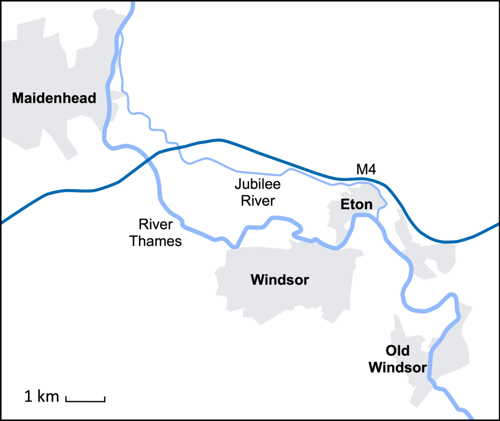
The Jubilee River is a flood relief channel on the River Thames. It was constructed to reduce the risk of flooding in Windsor and Eton by diverting water from the River Thames. It was funded by the Environmental Agency and cost £330 million. It opened in 2002, and at 11.17 kilometres long, it is the UK’s largest artificial channel and was designed to look like a natural river with meanders and shallow reed beds. It has five weirs (dams) along its course.

Social Issues
As the discharge of the River Thames between Maidenhead and Eton is reduced during high flow conditions, wealthy properties in Maidenhead and Eton are protected. However, this is at the expense of less affluent areas downstream at Wraysbury, beyond the confluence of the Jubilee River and the River Thames beyond Eton.
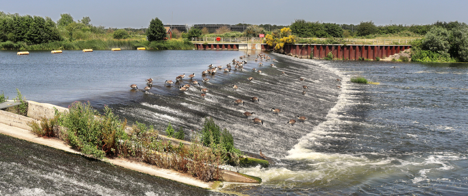
The Jubilee River is not a fully navigable river, as was promised. Weirs disrupt those using the river for leisure along its course.
Economic Issues
At £330 million, it is one of the UK’s most expensive flood defence schemes. It is one of four planned flood relief channels. However, the EA ran out of money to complete them all.
The weirs were damaged during floods in 2003, and their upkeep is expensive.
The flood relief scheme has transferred the problem of flooding downstream, where there was severe flooding in 2014. However, additional flood management is needed downstream.
Environmental Issues
Habitats located below the confluence of the Jubilee River and the River Thames were damaged following extensive flooding in 2014.
The concrete weirs look unattractive and spoil the natural environment.
Aquatic habitats are affected by algae that collect above the weirs.

Premium Resources
Please support internet geography.
If you've found the resources on this page useful please consider making a secure donation via PayPal to support the development of the site. The site is self-funded and your support is really appreciated.
Related Topics
Use the images below to explore related GeoTopics.
Topic Home
Next topic page, share this:.
- Click to share on Twitter (Opens in new window)
- Click to share on Facebook (Opens in new window)
- Click to share on Pinterest (Opens in new window)
- Click to email a link to a friend (Opens in new window)
- Click to share on WhatsApp (Opens in new window)
- Click to print (Opens in new window)
If you've found the resources on this site useful please consider making a secure donation via PayPal to support the development of the site. The site is self-funded and your support is really appreciated.

Search Internet Geography
Latest Blog Entries
Pin It on Pinterest
- Click to share
- Print Friendly
Jubilee River
Coastal, waterways and wetlands
Design and construction a new river channel to take overflow from the River Thames and so alleviate flooding in and around the towns of Maidenhead, Windsor and Eton.
International Riverprize 2010; Royal Town Planning Institute Award for Planning Achievement 2002; Institution of Civil Engineers Award 2002
Environment Agency- Richard Copas, National Environmental Assessment Service |Consultant leads Chris Blandford Associates (Design) |Jacobs (Construction) |Environment Agency RPS Clouston
The Royal Borough of Windsor and Maidenhead and Slough Borough Council
Circa £100 million
Environment Agency
Seed was collected from local areas, germinated and grown on in Lincolnshire before being returned and planted on site making it one of the most well planned and managed local provenance planting schemes ever undertaken, including approximately 250,000 trees.
The scheme required the excavation of material from most of the 7 mile channel length. This material was reused to create two raised areas of land with panoramic views of the surrounding area including Windsor Castle. The raised areas are located in part on what was previously the sludge drying beds of Slough Sewage Treatment Works, This central location was used as a hub for the materials management in the scheme with the channel being excavated from each end towards the hub to avoid intensive use of the highways in the area. The channel and its margins in this area now form Dorney Wetlands, in a transformed landscape that is now a honeypot to people and wildlife.

Approximate Map Location
- International
- Education Jobs
- Schools directory
- Resources Education Jobs Schools directory News Search

Physical landscapes in the UK AQA - Flood management case study - Jubilee river flood relief channel
Subject: Geography
Age range: 14-16
Resource type: Worksheet/Activity
Last updated
18 September 2018
- Share through email
- Share through twitter
- Share through linkedin
- Share through facebook
- Share through pinterest

Physical landscapes in the UK AQA 1-9 course (Scheme of learning)
17 outstanding lessons and two assessments for the physical landscapes in the UK module for the new AQA 1-9 course.
- UK relief, rivers and landscape
- Coastal processes (1)
- Coastal processes (2)
- Coastal landforms
- Coastal landforms resulting from erosion
- Coastal landforms resulting from deposition
- Coastal landforms case study - Dorset Coast
- Coastal management
- Coastal management case study
- Fluvial processes
- River profiles
- River landforms formed by erosion
- River landforms formed by deposition
- River landforms case study - River Tees
- River flooding
- Flood management
- Flood management case study - Jubilee river flood relief channel
Tes paid licence How can I reuse this?
Get this resource as part of a bundle and save up to 19%
A bundle is a package of resources grouped together to teach a particular topic, or a series of lessons, in one place.
Physical landscapes in the UK AQA 1-9 course (Scheme of learning) 17 outstanding lessons and two assessments for the physical landscapes in the UK module for the new AQA 1-9 course. UK relief, rivers and landscape Coastal processes (1) Coastal processes (2) Coastal landforms Coastal landforms resulting from erosion Coastal landforms resulting from deposition Coastal landforms case study - Dorset Coast Coastal management Coastal management case study Fluvial processes River profiles River landforms formed by erosion River landforms formed by deposition River landforms case study - River Tees River flooding Flood management Flood management case study - Jubilee river flood relief channel
Your rating is required to reflect your happiness.
It's good to leave some feedback.
Something went wrong, please try again later.
This resource hasn't been reviewed yet
To ensure quality for our reviews, only customers who have purchased this resource can review it
Report this resource to let us know if it violates our terms and conditions. Our customer service team will review your report and will be in touch.
Not quite what you were looking for? Search by keyword to find the right resource:

IMAGES
COMMENTS
The Jubilee River is a flood relief channel on the River Thames. It was constructed to reduce the risk of flooding in Windsor and Eton by diverting water from the River Thames. It was funded by the Environmental Agency and cost £330 million.
The Jubilee River flood relief that was created to divert water from the River Thames, so the Thames wouldn't overflow its banks. It is 11.7 km long, 50 m and cost £110 million to build. It was created to look and act like a natural river
The ‘Jubilee River’ (named in honour of the Queen’s Golden Jubilee in 2002) was constructed in the late 1990s and early 2000s to take overflow from the River Thames in order to alleviate flooding of areas in and around the towns of Maidenhead, Windsor and Eton. It is the UK’s biggest man-made river and cost over £110 million.
The document discusses the Jubilee River flood alleviation scheme in the UK. It was designed to reduce flooding along the River Thames near Maidenhead, Windsor, and Eton through the construction of a 12 km long relief channel. Unlike traditional concrete channels, the Jubilee River was designed to look and function like a natural river through landscaping and the inclusion of islands, shallow ...
The Jubilee River is one of the most significant fluvial flood risk management schemes, in terms of scale and investment, in the UK. It incorporates a wide range of aspects including significant areas of wetland and marginal habitats, a national cycle route, bridleways, and a significant length of the Thames long distance footpath.
However, this is at the expense of less affluent areas downstream at Wraysbury, beyond the confluence of the Jubilee River and the River Thames beyond Eton. The Jubilee River is not a fully navigable river, as was promised. Weirs disrupt those using the river for leisure along its course.
The Jubilee River is an artificial flood-relief channel in southern England. It is 11.6 km (7.2 mi) long [ 1 ] and is on average 45 metres (148 feet) wide. [ 2 ] It was constructed in the late 1990s and early 2000s to take overflow from the River Thames and so alleviate flooding to areas in and around the towns of Maidenhead , Windsor , and ...
Jubilee River Scheme . Revise: GEOGRAPHY . gcserevisionbuddy.co.uk/geography/river-landscapes Summary: CASE STUDY
The Jubilee River flood relief that was created to divert water from the River Thames, so the Thames wouldn't overflow its banks. It is 11.7 km long, carries 180 cubic metres of water and cost s£110 million to build. It was created to look and act like a natural river
Subject: Geography. Age range: 14-16. Resource type: Worksheet/Activity. Darran Girling. 3.33 7 reviews. ... Flood management case study - Jubilee river flood relief ...